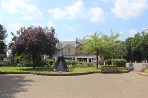
Royal Square
You can learn more about points of interest on the route by clicking on the bold text in the narrative - where it occurs. Use your web browser's back button to return to this page.
Royal Square is the site of the once magnificent Royal Hotel and Winter Gardens - with it's vast glazed roof - that dominated the centre of the Spa until destroyed by a landmine in 1942, along with the associated shops and flats.
During that fateful raid, troops normally billeted there were away on manoeuvres, otherwise the death toll would have been tragic. Apart from the two landmines dropped on this occasion, Woodhall Spa was only hit by incendiaries throughout the rest of the war, despite frequent air-raid warnings.
The half-timbered features of the Mall and buildings near it give some idea of the style of the Royal Hotel..
Now the area houses the official memorial to the famous Dambusters Raid by 617 Squadron in 1943. The Squadron Officer's Mess for part of the war was at nearby Petwood House Hotel, which still has a Squadron Bar.
You can download and print these walks and the village map if you wish. You will however, need PDF reader software.
 Download Woodhall Spa village map
| Walks | . | . | |
|---|---|---|---|
| 1. Town, Woods & Fields | 2. Cottage Museum | 3. The Manor House | 4. Links & Lanes |
| 5. The Spa Trail | 6. Ostler's Plantation | 7. Woods & Water | 8. The Village |
| 9. A walk to the past | 10. The Viking Way & Water Rail Way | 11. The Heritage Trail |
Checked 2 Jan 24
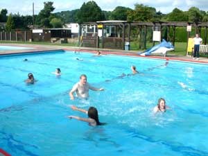
Jubilee Park Swimming Pool
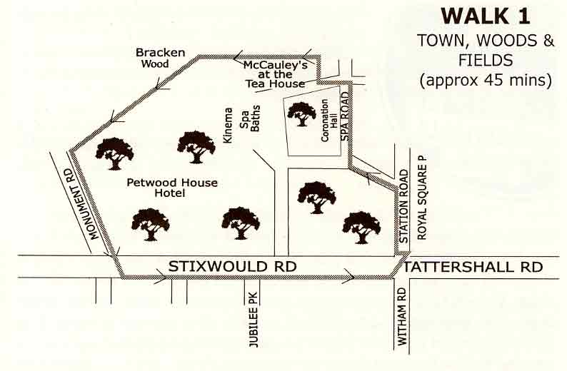
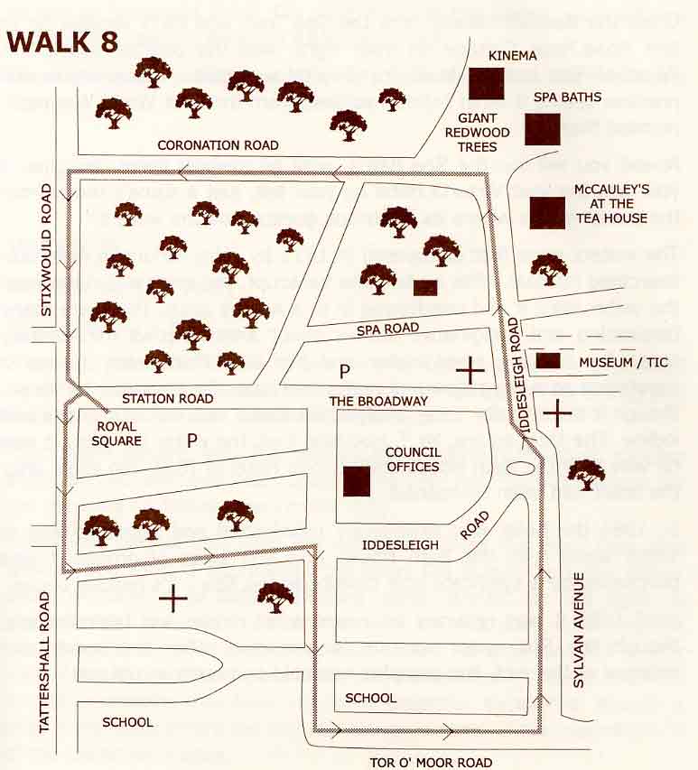
1. Town, Woods & Fields
Start from Royal Square - Grid Reference: TF 193631
From Royal Square, head east along Station Road, bearing left just after the Mall onto Spa Road, passing the public conveniences on the left, keep to the right.
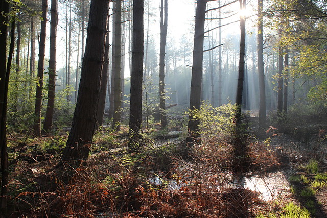
On the left are some of the woods from which our village gets it's name. Look out for squirrels, there are plenty here. Until recently they were our native red, but sadly only grey squirrels are found now. The woods are a mixture of pine, oak, beech, birch, ash and holly, though originally they were specifically pinewoods. There are some lovely paths through these woods if you choose to take them. Listen for the woodpeckers.
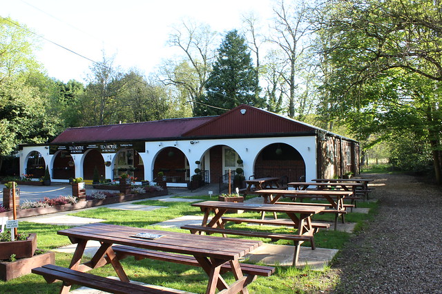
The Tea House in the Woods
On the left you will pass the Coronation Hall, with a large monkey-puzzle tree and sweet chestnut tree beside it. In Woodhall's heyday as a fashionable Edwardian Spa, This was the site of the famous Victoria Hotel, visited by the cream of society. It was destroyed in a fire on Easter Day 1920, and it's ruin marked the end of a golden era for the Spa. After passing the Coronation Hall, bear left with the road. You will see the Tea House in the Woods on you right and the derelict Spa Baths ahead. The footpath you will take is signposted and on the right hand side, slipping between a modern house and the Tea House restaurant.
This attractive, sheltered right of way bends left behind the restaurant and passes along the wooded boundary of the Spa buildings, the Kinema and the Petwood House Hotel on the left, and the Bracken Golf course on the right
It's a peaceful country walk with glimpses of a wide variety of wildlife for the observant. In the late summer and early autumn, blackberries abound.
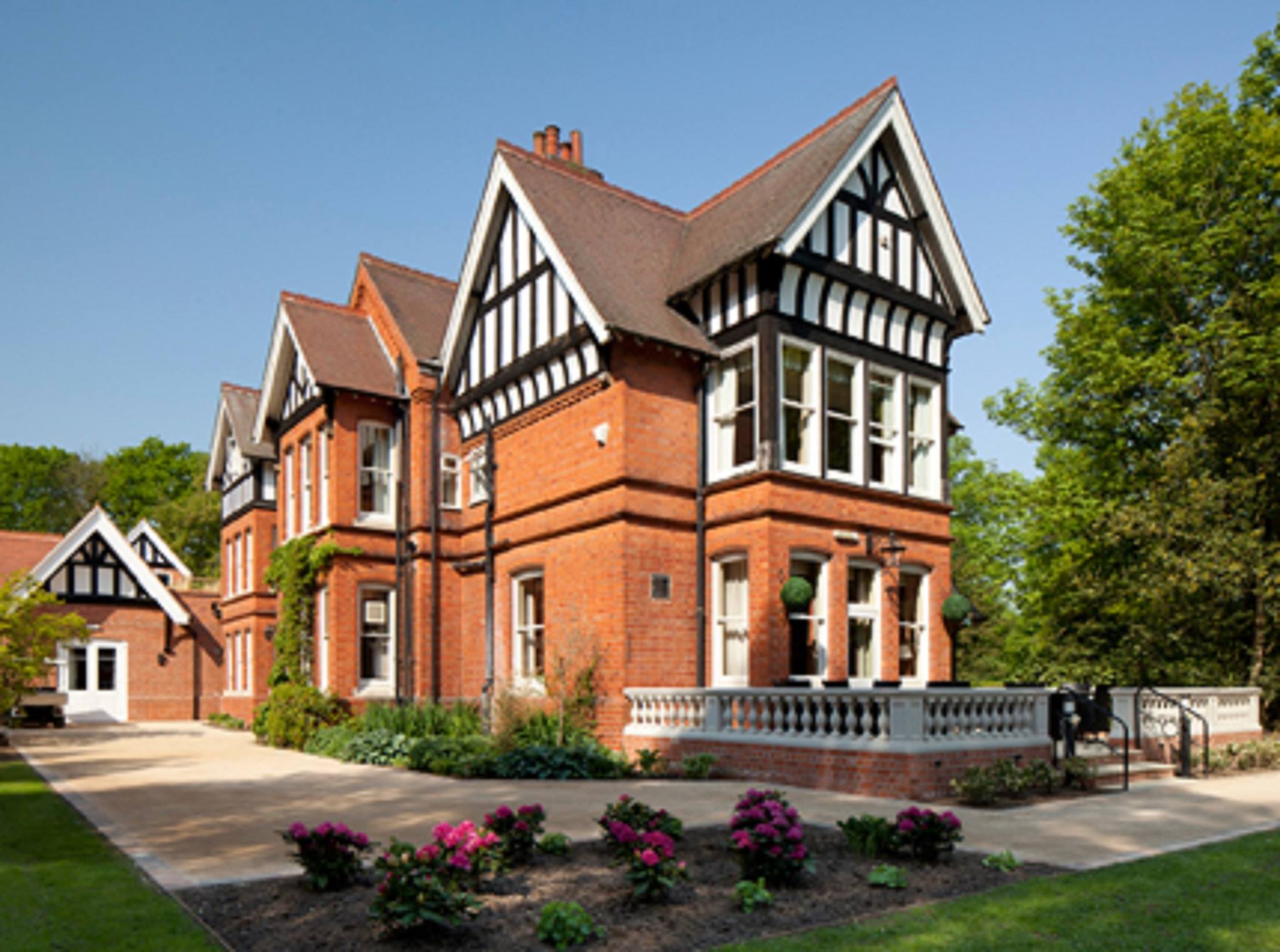
It may be advisable to take a stout stick as the undergrowth can be vigorous along this stretch ... until it is cleared each year. Soon after the left hand boundary of the walk opens out, the path takes a sharp left turn to run along the woodside on the left and the golf course on the right. Before turning, pause and glance over the gate up the broad avenue in Bracken Wood, which is private. This avenue is reputed to follow the line of a Roman Road that gave access to a Roman brickworks nearby. Follow the path down to the gate onto Monument Road. Turn left along this lane, passing what used to be the walled kitchen gardens of the Petwood when it was a private country house (now a small group of private houses) , then turn left again onto Stixwould Road. (Monument Road has no footpath, but the grassy verges are wide and firm under foot).
The walk down Stixwould Road can be taken down the tree-lined metalled path on the right hand side, or on the wide, grassy verge on the left, bordered by woods. Along Stixwould Road walkers will pass Jubilee Park, created for Woodhall Spa in 1935 by Sir Archibald and Lady Weigall, who built the Petwood, and opened by Princess Marie Louise. Much of the original layout is retained today. It now includes an open-air heated swimming pool, tennis, bowling, putting, croquet, indoor multi gym and other facilities and is well worth a short detour. About quarter of a mile past the Park, Royal Square is reached.
Checked 2 Jan 24
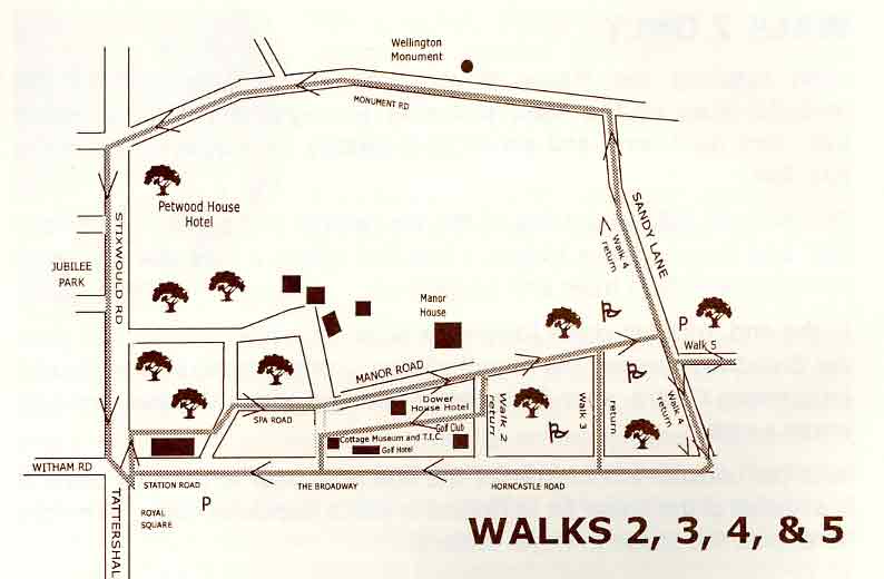
2, 3, 4 & 5 - Woods, Rhododendrons, Golf & Country Lanes
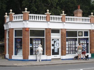
Robert Bell & Co
These four walks all start along the same route, following part of the Viking Way long distance footpath that passes through Woodhall. The walker may branch off at any of the four suggested points, according to preference. These walks pass through some of Woodhall's most beautiful scenery. From Royal Square, cross the road and take the path to Stixwould Road that goes behind the Station Road shops. Note the shop on the corner (Bell's the Estate Agent's), in 2006 the brick, stone and timber balustrade and fascia was reinstated and the roof re-covered.
The Dower House
You are now on Church Walk, so named because Edwardian visitors to the Victoria Hotel used it to walk to St Andrew's church. This stood in the churchyard in the centre of the village until it was demolished after the last war, when it was feared that the bombing had made it unsafe. At the end of Church Walk, carry straight on along Spa Road, with the pinewoods and Coronation Hall on the left. When the road bends sharp left to the Spa Baths, go straight ahead along Manor Road, past the Dower House Hotel.
The road is lined with lime trees on the left, beyond which the Bracken golf course and woods can be seen. This was originally parkland belonging to the Manor House. The Manor is now a luxury wedding and party venue, but served for several years as the headquarters of the National Farmers Union in Lincolnshire. Shortly before the house is reached, a standing of tall pines flanks the road on the right.
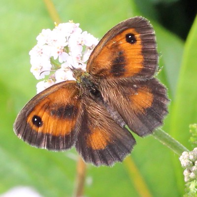
Gatekeeper Butterfly
Go to Walk 2 or read on for Walks 3, 4 & 5
Carry on past the Manor House, with its walled garden, and the gardener's cottage on the right. Note the huge spreading mature oaks on the left. In the early summer the rhododendrons in these private woods are a spectacular multi-coloured mass of flowers. A rhododendron hedge flanks the path as it runs alongside an enclosed field - this spot is a real sun-trap in warm weather and attracts a variety of butterflies and dragonflies. At the end of the field, the path carries on through the famous championship golf course. Walk 3 leaves at this point and follows the branch to the right, walks 4 and 5 continue straight on.
Go to Walk 3 or read on for Walks 4 & 5
Please keep your dogs on a lead now and have consideration for golfers as you follow the Viking Way through one of Britain's loveliest (some say THE loveliest) golf courses. Colonel Hotchkin who lived in the Manor House laid out the course. The path goes through copses of trees, havens for wildlife, and across fairways.
The sandy soil in this part of the Spa is evident in the patches of heather, gorse and broom that add their own colourful fragrance to this delightful walk.
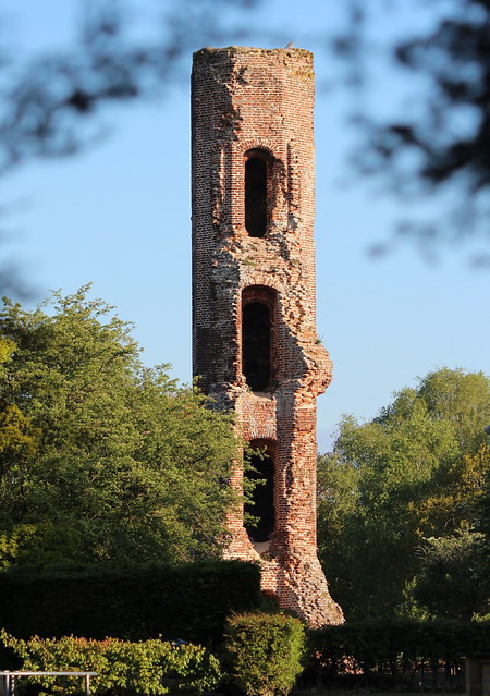
The Tower on the Moor
Across to the right you will see the Tower on the Moor, the Woodhall Spa emblem. It is believed to date from the 15th century as a lookout tower and hunting lodge for nearby Tattershall Castle. Originally a pond, or lake was created near it. There was also a secret passage - long lost - to Tattershall Castle. Unfortunately, it is not possible to walk up to the Tower unless you are playing golf. Near the end of the course, by an impressive group of scots pine, the path finishes in a piece of woodland and the walker leaves the golf course over a stile to Sandy Lane.
For a direct route back to the centre of Woodhall Spa, turn right upon leaving the golf course. A short distance down the lane, it joins the Horncastle Road. Turn right again here and take the path straight back into Woodhall Spa village centre, a distance of about one and a half miles.
Lovers of country lanes will wish you to turn left on Walk 4.
Go to Walk 4 or read on
If the walk through the golf links has left you interested in going further, then you are ideally placed to continue along the Viking Way.
Go to Walk 5 or read on
Download Woodhall Spa Walk 2, 3, 4 & 5
Updated 2 Jan 24
Walk 2 - Cottage Museum
40 minutes
Select link to view the start of this walk - Start
Upon reaching the Manor House, take the tarmac footpath on the right, just before a magnificent horse chestnut tree. Almost immediately turn right again onto the Spa Trail.
The footpath follows the track bed of the old railway and passes behind the Golf and Dower House Hotels. The Trail offers a pleasant sheltered stroll between high trees and hedgerows.
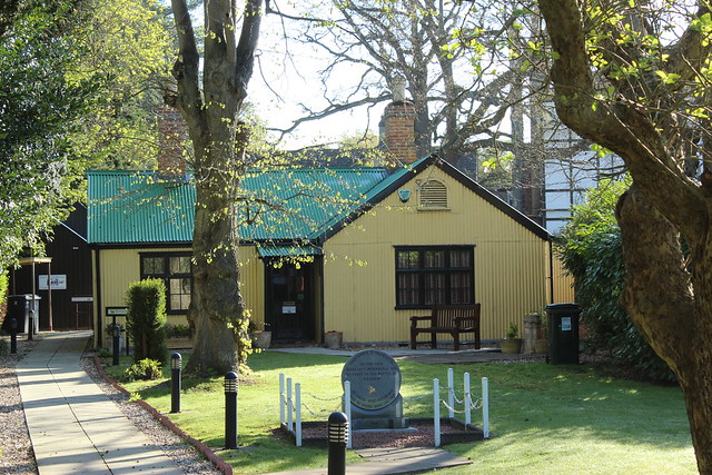
Cottage Museum
At the end, turn left and walk along Iddesleigh Road for a few yards, past the Woodhall Spa Cottage Museum and Tourist Information Centre, unitl you reach the Broadway. The Museum holds a variety of artifacts relating to the history of Woodhall Spa and bis open from Easter until the end of October, and well worth a visit.
Note the unusual architecture of the house on the corner. It is supposedly a replica of the house on the island of St Helena in which Napoleon died. Turn right here onto The Broadway and return to Royal Square via the shops
Select here to view the map for walks 2, 3, 4 & 5
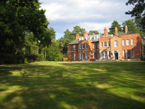
Woodhall Spa Manor
Walk 3 - The Manor House
1 hour
Select link to view the start of this walk - Start
Follow the path across the width of the golf course, passing between the 17th green and 18th tee, before crossing the 2nd fairway. The private track leading off to the left is the track bed of the former Woodhall Spa to Horncastle branch line. Remember to consider and give way to golfers and ensure your dog is on a lead here. This path joins Horncastle Road – a road lined with trees like many of the avenues in Woodhall Spa. There is a surfaced path all the way back to the village centre, about a mile away. The flowering cherries make this particularly attractive in the spring. Soon after you join Horncastle Road it becomes ‘The Broadway’, and you will pass the Golf Hotel and shops on the way back.
Select here to view the map for walks 2, 3, 4 & 5
Download Woodhall Spa Walks 2, 3, 4 & 5
Updated 2 Jan 24
Walk 4 - Links & Lanes
1 - 1.5 hours
Select link to view the start of this walk - Start
Follow the lane to its end, just over half a mile, to a charming group of cottages. Turn left, down Monument Road. (The road to the right leads to Old Woodhall, from which the more recent Spa borrowed its name). Soon after you turn, you will see the Wellington Monument on the right. The
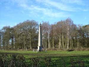
Wellington Monument
Monument stands in front of Waterloo Wood, an oak wood grown from acorns sown after the famous battle of 1815. Built in 1844 by Colonel Richard Elmhirst, the monument faced his residence in West Ashby.
Though neither Sandy Lane nor Monument Road has footpaths, the verges, particularly down Monument Road, are wide enough to walk on and avoid the traffic, though both are generally quiet roads. Upon reaching Stixwould Road turn left and follow the footpath back to Royal Square. On your left you will pass the Petwood Hotel, and on the right, Jubilee Park with its gardens and varied recreational facilities.
Select here to view the map for walks 2, 3, 4 & 5
Download Woodhall Spa Walks 2, 3, 4 & 5
Checked 2 Jan 24
Spa Trail
Walk 5 - Spa Trail to Horncastle
Select link to view the start of this walk - Start
When you reach the gate at the end of the Golf Course, turn right and walk along Sandy Lane for two hundred metres, and then left onto the signposted Spa Trail (& Viking Way) which from here follows the trackbed of the old Woodhall Spa to Horncastle railway line. The Spa Trail was resurfaced in 2009 to permit easy access by walkers, cyclists and wheelchair users. There is a small car park at this point and the first of a series of information boards and sculptures relating to the heritage of the line and the wildlife that can be seen along it. You can follow the trail as far as the market town of Horncastle if you wish, however, there is a picnic place and small car park about a mile along the trail which can also be accessed from the main Horncastle Road. On occasions this quiet route passes above the surrounding countryside (woods and fields) on an embankment and on others is down in a cutting, however it is possible to detect the early undulations that mark the very beginnings of the hillier wold country beyond Horncastle.
The first wood on the left, Highall and the later White Hall forestry plantation, are both named after moated halls that once stood there. Nature quickly reclaimed the old trackbed and it is now a sanctuary for all types of wild flowers and plants that are becoming rarer in our country lanes - from meadow sweet, and wild roses to willowherb. Spring is particularly colourful with celandines, primroses and wood anemones bordering the track.
After 1 3/4 miles the route passes under the Woodhall Spa to Horncastle road bridge and there is a marked change from woodland surrounds to open countryside and, on the right hand side, the disused Horncastle Canal. Horncastle railway terminus was demolished many years ago to make way for a housing estate, however the trail ends pleasantly on the banks of the Horncastle Canal and River Bain.
St Michael's Church, Martin
The track is certainly a more direct route to Horncastle than the main road. If you decide to return along the Viking Way, an interesting diversion is possible once you have passed under the old railway bridge. Look for the track up to the main road on the left, double back to cross the bridge, walk along the road for three hundred yards and then turn left for the 'village' of Martin. The road ends just beyond St Michael's, the little church with a colourful mix of stone and brickwork. Continue straight ahead and take the bridleway heading west for Thornton, White Hall and Highall Woods. The bridleway rejoins the Spa Trail approximately half a mile before reaching Sandy Lane. At Sandy Lane the walker can take one of the routes suggested for walk 4.
Select here to view the map for walks 2, 3, 4 & 5
Download Woodhall Spa Walks 2, 3, 4 & 5
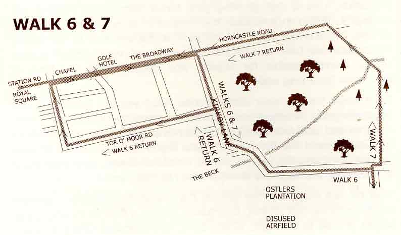
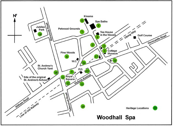
Walk 6 - Ostler's Plantation & Walk 7 - Woods & Water
Start from Royal Square - Grid Reference: TF 193631 (or park in Ostlers Plantation - Grid Reference: TF 216629)
Walk 6 goes to, and around, the Forestry Commission's Ostler's Plantation, now a fast growing pine forest with numerous walks within it. It also encompasses the remains of Woodhall Spa's wartime airfield. If preferred, there is a car park at the entrance to the forest, which cuts over two miles off the total walk and makes instant access to the woods possible for anyone who doesn't have the time or inclination for a long walk.
Initially walk 7 follows the route of walk 6 but then it follows a right of way that connects Horncastle road to Kirkby Lane. It crosses pine forest and deciduous woodland, and some small water courses
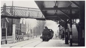
Photo 7 - View west from the platform. Post Office on left. (Photo courtesy of Woodhall Spa Cottage Museum)
From Royal Square, walk along Station Road and the Broadway. The point where the two meet was, until recent years, the site of the railway crossing and until the late 50's a station was situated behind the Broadway shops in the centre of the Spa. This was one of two railway stations serving the village, the second was at Kirkstead Bridge, over a mile west of the village centre. Unfortunately, no rail links to Woodhall Spa have survived. Note the refurbished canopies above the six shops that once fronted the railway station.
Walk on past the shops, the church, the chapel, the Golf Hotel and the entrance to the golf course. Eventually, almost a mile from where you began, a road to the right, Kirkby Lane, is signposted Kirkby on Bain.
Select here for Walk 7 - Woods and Water
Kirkby Lane
Walk 6 - Turn right here. Follow this shady wood-lined road, soon leaving the residential area behind. On the left is a woodland camping site for the scouts, and on the right the cemetery. The lane winds and crosses a small stream - the Beck - before straightening and rising. to the right, behind the oak trees, the pine woods can be seen. The entrance is about a quarter of a mile further along, on the right, just after a bungalow on the left. It occurs just before the brow of the hill. A short track leads to a small car park. Notice the strip of moorland just before the car park. In August and September it is purple with flowering heather amongst a sea of fine, creamy grasses.
The Kirkby Moor Nature Reserve borders this plantation, the larger portion of it being on the Kirkby on Bain side. Ostler's Plantation is named after the agent of Mr John Parkinson, whose abortive attempts to discover coal led to the founding of the Spa. Early in the 19th century, Mr Ostler planted a fir and oak forest in the area, which he purchased from Parkinson when his employer became bankrupt. Most of that original forest was burnt or cut down. Walking in the present plantation is ideal for the wettest weather as the silver sand drains quickly. Now the trees are growing taller and being thinned out, grasses and ferns are springing up between the pine-needles.
The walks of differing lengths, are marked out here, and include parts of the old airfield. The geometric grid on which the forest is laid out, however, makes it easier to find your way along the wide rides and smaller avenues.
Ostler's Plantation
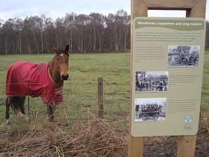
The airfield constructed in 1942, is one of more than fifty that were operational in Lincolnshire during the last war. Some of it has been planted with conifers and lies beyond the more mature forest, about half a mile from the car park. The taxiways, and many of the bunkers and standings are still intact, though overgrown by bracken, elderberry and bramble. It's rich with wartime memories. During 1944 and '45 the famous 617 'Dambuster' Squadron flew Lancaster bombers from here - the Petwood was their Officer's Mess. If you're lucky you may, in fact, see overhead the last remaining flying Lancaster in the UK (the aircraft's distinctive throaty roar is unmistakeable). The aircraft belongs to the Battle of Britain Memorial Flight and is based at RAF Coningsby, a few miles to the south.
At the edge of the planted airfield you can look over the fields south to Tattershall Castle, Kirkstead Abbey ruin to the west and across gentle undulations to the houses of Woodhall Spa. This is an ideal spot to view the beautiful Lincolnshire sunsets - and it must have been a welcome site to those returning from the ill fated battle of Arnhem!
One word of warning, in the summer adders can sometimes be found basking on the airfield, so take care with children and dogs. Retrace your steps, or follow the marked routes, back to the car park at Ostler's Plantation. If you are walking back, return to Kirkby Lane and turn left, retracing your footsteps until you reach the 30mph limit. Follow the footpath until you reach Tor 'o' Moor Road, to the left. Turn here. This residential road is connected to the main Broadway by several avenues that branch to the right. You may take one of these, or choose to follow the road, which eventually swings sharp right to become Stanhope Avenue.
Follow this up to the T-junction with the Broadway and the shops, passing the Woodhall Spa Hotel. This hotel was previously known as the Eagle Lodge Hotel. Prior to that it served as a County Council home for the elderly. Royal Square is only a short distance away.
Select here to view the map for walks 6 & 7
Visit the Forestry England website: www.forestryengland.uk/
Greater Lincolnshire Nature Partnership (GLNP) website: https://glnp.org.uk/our-services/nature-strategy/heathland-and-peatland
![]() In Jubilee Park or Ostler's Plantation
In Jubilee Park or Ostler's Plantation
Download Woodhall Spa Walk 6 & 7
Checked 2 Jan 24
Walk 7 - Woods & Water
The initial part of this walk is identical to Walk 6. Select link to view start
Walk past the entrance to Ostler's Plantation, and a few feet further on, to the left, you will see a drive leading to some houses. Follow this through a small patch of deciduous woodland until reaching a gate to the plantation proper, also called Ostler's Plantation. Go through this and straight ahead. The trees here are smaller than in the nearby forest in Walk 6. Follow this path until it bears to the left, then turn with it. Just before you do turn left you will see ahead, just beyond the pines, the birch and oak of the Moor Farm Nature Reserve.
The earth is still sandy here; further on it is inclined to become muddy in wet weather. Dividing the young pine, some mixed woodland and an area of very tall, mature Douglas Firs and Christmas Trees, the Beck passes under the path - this is the same stream met lower on its course on the way up Kirkby Lane.
To your right you will now be able to see through the trees the chalets of Bainland Park, to the left the tall pines tower over the path. Follow the track straight ahead, where the ground rises. You will then cross into a broad band of deciduous wood - look out for the Lillies-of-the-Valley in May.
The path turns sharp right to follow the perimeter fence of Bainland Park. If you fancy refreshments, a footpath leads into Bainland Park approximately 100 yards after the sharp right turn. Otherwise continue on, keeping the poultry farm to your right, until you reach Horncastle Road beside the farm gates. Turn left onto Horncastle Road. After about 100 yards, on the right hand side to the rear of one of the bungalows, you will be able to see the Tower on the Moor - the Woodhall Spa emblem. It is believed to date from the 15th century as a lookout tower and hunting lodge for nearby Tattershall Castle. Originally a pond, or lake was created near it. There was also a secret passage - long lost - to Tattershall Castle. Unfortunately, it is not possible to walk up to the Tower unless you are playing golf. Continue along Horncastle Road, The Broadway and Station Road, back to Royal Square.
Select here to view the map for walks 6 & 7
Download Woodhall Spa Walk 6 & 7
Walk 8 - The Village - a half hour ramble through the heart of Woodhall Spa
Start from Royal Square - Grid Reference: TF 193631
From Royal Square, take the footpath south along Tattershall Road, crossing the entrance to Victoria Avenue on your left. Soon after, look for a small wooded walk, on the left also - Long Avenue (it is signposted); take this. Some of this walk's horse chestnut trees remain.
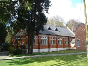
Roman Catholic Church
The walker will pass the Roman Catholic Church of St Peter and Our Lady on the right. At the end, turn right and follow Stanhope Avenue as it passes part of St Hugh's Preparatory School and then turns sharp left to become Tor 'o' Moor Road.
Walk along here for a short way and take the next left, Sylvan Avenue. This shady way winds itself back to the Broadway passing St Peter's Church on the corner. Cross the Broadway and carry straight on past the former Methodist Chapel and the Cottage Museum. The house on the corner, on the right, was of special significance to Napoleon, see walk 2.
Cross the disused railway, now the Spa Trail, and carry straight on to Spa Road. Rose Cottage on your right, was the original hospital in Woodhall Spa before the Alexandra Hospital was built - it scarcely seems possible seeing it now! Injured soldiers from the First World War recuperated there.
Ahead you will see the Spa Baths, walk on towards them. Imagine, if you can, the vast Victoria Hotel on your left, just a stone's throw from the pump rooms where its illustrious guest took the waters.
John Parkinson, who was searching for coal, first discovered the waters in 1811. After he became bankrupt, the shaft closed and the water filled it and overflowed in to a nearby ditch. There are many fascinating and imaginative stories about arthritic cows miraculously cured by drinking pond water and the like. It certainly gained a reputation as a purgative and restorer of appetite amongst the locals, though it tasted salty. Later analysis showed it was rich in bromide and iodine. The local squire, Mr.T Hotchkin took the water for gout. It was he who built the Bath House and Victoria Hotel in 1834, ten years after the shaft had been re-opened.
In 1884 the hotel was extensively refurbished and improved and in 1887, along with the Bath House and 100 acres of ground it was purchased by a syndicate who developed the Spa - it's heyday began.
Until 1983 it was retained as a centre for physio and hydrotherapy, though the Spa water was no longer used. After the spectacular collapse of the well, the complex was sold and remained derelict until 2019.
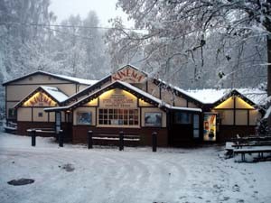
The Kinema in the Woods
Walk on past the baths and follow the road, as it turns left you will see our unique Kinema, built originally as an Edwardian concert hall overlooking tennis and croquet lawns and a bandstand in the Spa Grounds between the Petwood House Hotel and the Victoria Hotel. The projection is from behind the screen, so the best seats are in the front. When it opened in 1922 it was one of only 68 in the whole country. Recent extensions, in keeping with the original design of the building, have added a second and third screen (a multiplex in the sticks). Note the two giant redwood trees nearby.
Follow the road as it winds to the left, then as it bears right through the woods to Stixwould Road. On your right, in the spring, you will see some of the famous Petwood Rhododendrons.
On reaching Stixwould Road, turn left for a short walk back to Royal Square.
Select here to view the map for walk 8
Checked 2 Jan 24
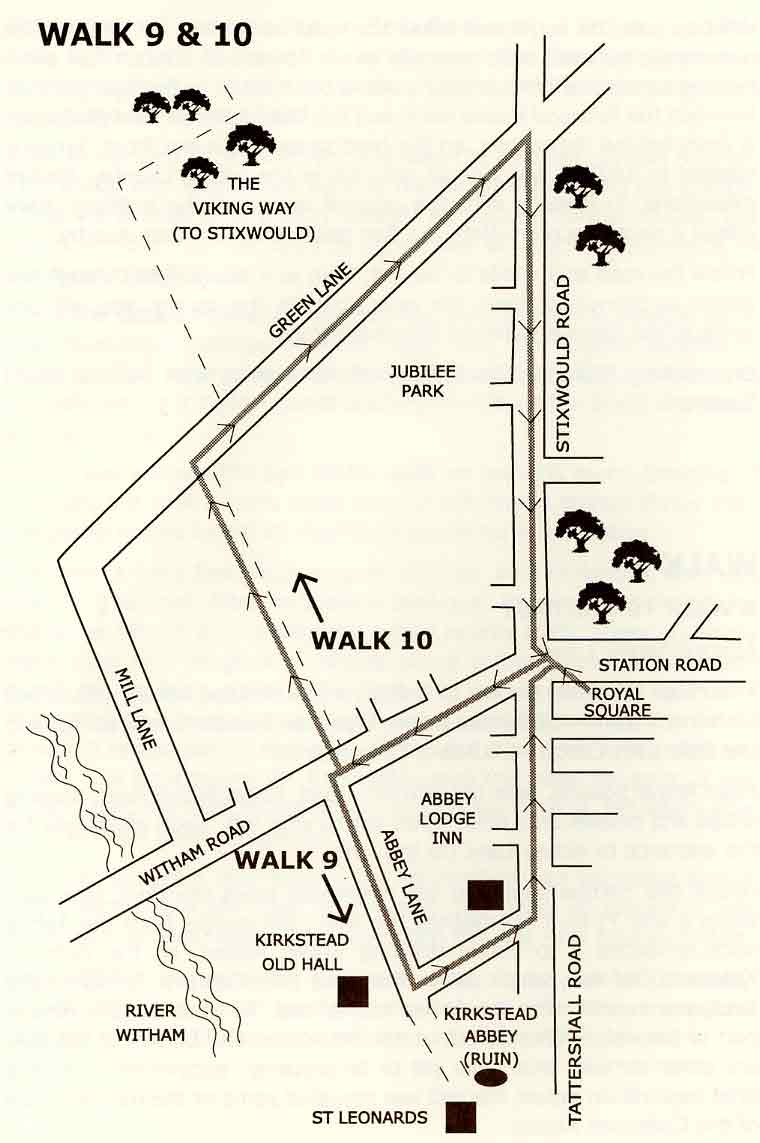
Walk 9 - A walk to the past
Start from Royal Square - Grid Reference: TF 193631
Approx 1 hour
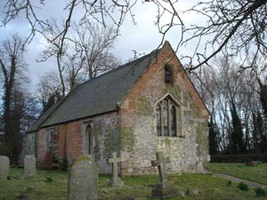
This route takes the walker to the ruins of Kirkstead Abbey, (dissolved by Henry VIII over 300 years before Woodhall Spa came into being) and the little 13th Century Church of St Leonards.
From Royal Square, take the Witham Road, towards the river, passing shops and houses until fields open out to your left. Soon after, look for the entrance to Abbey Lane (to the left).
Follow this narrow lane. You will eventually cross the Beck (see also walks 6 and 7) as it approaches the river; the monks from the Abbey once re-routed it to obtain drinking water. Ahead, on the right, is Kirkstead Old Hall, which dates from the 17th Century. Following the land, you cannot miss the Abbey ruin ahead. All that remains now is part of the Abbey Church, but under the humps and bumps of the field are other remains that have yet to be properly excavated, though a brief exploration before the last war revealed some of the magnificence of the Cistercian Abbey.
Kirkstead Abbey
Beyond is the superb little Church of St Leonards (the patron saint of prisoners), believed to have been built as a Chantry Chapel and used by travellers and local inhabitants. The Cistercians were great agriculturalists and wool from the Abbey lands commanded a high price for its quality. A whole community of craftsmen and labourers would have grown up around the Abbey as it gained lands and power. Sadly the remains were used as a source of building stone for centuries - Abbey Farm is built from the stone.. The last abbot was executed in 1539, 400 years after the Abbey was founded.
Having savoured the ancient site, follow the Abbey Lane on round, past the Abbey Lodge Inn to join Tattershall Road. Across the fields, ahead, the outline of Ostler's Plantation can be seen, which backs Woodhall Spa's wartime airfield.
Turn left and walk straight down into the centre of the present day Spa. On the way you will pass ponds, dug in the last century to obtain clay to mix with the poor soil.
Select here to view the map for walk 9
Checked 2 Jan 24
Walk 10 - The Viking Way & Water Rail Way
The Viking Way is a 147 mile (235km) footpath linking Barton-upon-Humber in the north to Oakham in the south.
From the Humber Bridge this gentle route heads south along the Lincolnshire Wolds through territory once occupied by Vikings to Horncastle, Woodhall Spa and Lincoln, finishing near Rutland Water. Almost the entire route forms part of European path E2.
Start from Royal Square (Grid Reference: TF 193631) is on the route.
To follow the route 'south' to Lincoln and Oakham, cross Station Road by the mini roundabout and head north along Stixwould Road (this misses a section running through a new housing estate). Walk past Jubilee Park and the Petwood Hotel and turn left onto Green Lane. Continue westwards past a few houses and the northern boundary of Jubilee Park camping and caravanning ground.
Woodhall Spa is particularly fortunate in still retaining some fine hedgerows with all their abundant wildlife. Along Green Lane you too will be able to appreciate them. Honeysuckle, wild roses, blackberries, elderberries and hawthorns all abound in season. Walking quietly, stoats and weasels sometimes scuttle across the road and there are inevitable rabbits and wild birds. Some times moorhens and even ducks can be seen near the ponds and drainage ditches.
The Viking Way cuts across Green Lane approximately three-quarters of a mile down. Turn right onto the track and follow it north until it rejoins Stixwould Road. Turn left onto the road and left again after two hundred yards onto Green Lane (a different one). Follow the lane to its very end (1 mile) alongside the former Stixwould Railway Station and Signal Box on the Water Rail Way.
The Water Rail Way, is the latest link in the Lincoln to Boston Footpath and Cycleway project, completed in August 2007 by Sustrans (Sustainable Transport). It created an off-road route along the River Witham from Kirkstead Bridge near Woodhall Spa to Lincoln via Bardney. The route is appropriately named 'Water Rail Way' because it is based on the track bed of the disused Boston to Lincoln railway line and the secretive 'Water Rail' bird has been spotted along the river bank. Now that the track is complete the existing Harwich to Hull Cycleway has been rerouted along it.
Turn left on the track and head south for Kirkstead Bridge. Lincolnshire Longwool sheep are usually to be found grazing beside this stretch of the track and you will find that one particular group are not easily intimidated and will insist in crossing in front of you. Eventually you will reach a gate and Kirkstead Bridge will be visible in the distance. Continue along the track and pass through another gate near the pumping station. Just in front of you and just before the bridge, are the moorings which attract a variety of colourful barges and pleasure craft during the summer months.
At this point you have the option of returning to Royal Square by a quiet country lane and Jubilee Park or via the old railway station, the former Railway Hotel (now the Ragged Apron Cafe) and Witham Road.
Option 1 - Country Lane
Turn left through the gate and onto the Drainage Board track next alongside the pumping station. A walk of 200 yards through two more gates will bring you to Mill Lane. Turn left here and follow the road round to the right onto Green Lane. Half a mile will bring you back to the point at which you joined the Viking Way.
On the way as the road sweeps down into the Spa, you will pass the Jubilee Park. You may decide to stop and watch the bowls, tennis, putting, croquet or cricket in season, perhaps to look in on the open air heated swimming pool, sit in the gardens or take refreshment in the cafe.
Option 2 - Witham Road
The Water Rail Way track ends just beyond the bridge alongside the former Woodhall Spa Junction Station buildings (now in private ownership) and the old ferry crossing point. Turn left through the old railway crossing gates and past the former Railway Hotel (now a cafe). Those heading for Boston will now have to cross the bridge and continue their journey south on the country lane running along the river bank top.
To return to Woodhall Spa, walkers should continue east along Witham Road. Royal Square is approximately one mile from the river bank.
Visit the Ramblers Association website: www.ramblers.org.uk
Updated 12 Jan 25
Walk 11. The Woodhall Spa Heritage Trail
Follow the instructions below to join the heritage trail
The trail can be started at any location, but we suggest you also visit the Cottage Museum to see the photographs taken by John Wield during the heyday of the Spa and items associated with this unique Victorian Spa town.
The Trail is just one of several projects in the hands of the Woodhall Spa Parish Council sponsored Heritage Committee. Click here if you are interested in the committee or their projects.
How well do you know Woodhall Spa?
See if you can identify the location of these architectural features and items of street furniture! Or find the Letterbox (coming soon)
Find out more about the Woodhall Spa Conservation Area